Publication-2023-UAV
Learning UAV-Based Above-Ground Biomass Regression Models in Sparse Training Data EnvironmentsKröber, F., Garcia, G. F., Guiotte, F., Delerue, F., Corpetti, T., & Lefèvre, S. (2023)IGARSS 2023 – 2023 IEEE International Geoscience and Remote Sensing Symposium, 3322–3325. https://doi.org/10.1109/IGARSS52108.2023.10281513 conference proceedings
Publication-MA
Agricultural parcel delineation based on multitemporal Sentinel-2 data – Machine and deep learning approaches for instance segmentationKröber, F. (2023) Master’s Thesis, Paris-Lodron University Salzburg & University Bretagne Sud theses
Publication-BA
Variability of radar backscatter on the field scale – An analysis based on multitemporal Sentinel-1 data Kröber, F. (2021) Bachelor’s Thesis, University of Cologne theses
S-1 based crop analyses

Processing pipelines for the calculation of backscatter intensity, polarimetric decomposition parameters and coherence values are presented. Analyses regarding the informative value of these SAR features are exemplified by analysing timeseries for a few hundred fields. Correlations to the phenological development of the crops are made and random forest-based classifications are performed.
Internship – UAV-based regression of biomass

Comparison of three different machine/deep learning approaches to perform regression for fractional vegetation coverage, vegetation height and vegetation volume. Tackling the issue of sparse training data vs. high model complexity
UAV-based DSM & Orthophoto generation

Illustration of the workflow as well as the intermediate products in the creation of terrain models based on drone data. Application example based on a small-scale river bed within a forested area.
EO Summer School 2022

Summary of the contents of the one-week summer school on state-of-the-art use of various remote sensing data
S-1 based DEM generation

Investigation into the usability of radar-based terrain models for analysing the landscape-altering effects of the Brumadinho dam collapse (Brazil, 2019)
Geopython 2022

Impressions from the conference on python in the field of spatial analysis. Interesting individual contributions are briefly summarised. They are grouped into broader categories and where links to related themes and methods came to mind corresponding material is added.
Living Planet Symposium 2022

Impressions from the world’s largest conference in the field of remote sensing and Earth observation. Excerpts from individual, interesting sessions in the field of agricultural research and big earth observation.
SAR-based crop classifications – Literature review

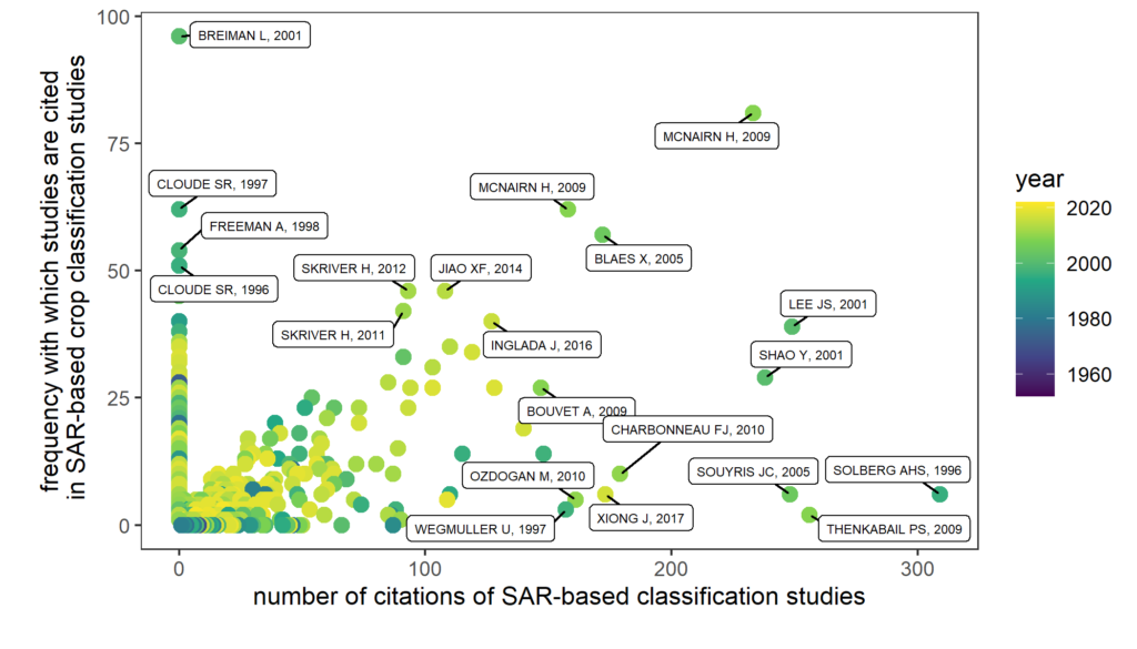
Quantitative, bibliometric analyses on the existing literature of SAR-based crop classifications. Analyses of temporal and spatial characteristics of the scientific corpus and identification of the most significant publications.
Tweet mapper

Java app that maps tweets contained in a .csv file as a timeseries representation in Google Earth.
Hurricane track forecasts

6h forecasts of the next positions of hurricanes in the Atlantic Ocean. Taking into account the motion history of the hurricanes recorded up to that point as well as their current properties, feature sets are created that are then used to train and evaluate various machine learning models.
Visibility analyses

Analysing the views along austrian hiking paths with consideration of the landuse within viewsheds. Presenting the map results as well as descriptive statistics in form of a simple dashboard (R Shiny).
Solar radiation analyses

Performing a multitemporal classification of Sentinel imagery to extract vineyards. Subsequently, analysing the significance of irradiation intensity and duration for the location of vineyards. Using random forest as an embedded feature selection method.
